Search the ArchivesNavigation Contact InformationThe Citizen Newspapers For Advertising Information Email us your news! For technical difficulties |
PTC getting busy with cart path repavingThu, 03/30/2006 - 5:21pm
By: John Munford
 As the temperature warms up, so does the work on Peachtree City’s golf cart paths. This year, city crews will construct nearly six miles of golf cart paths, almost all of which will involve replacing existing path that’s in bad shape, according to Public Works Director Tom Corbett. Some 11.2 percent of the city’s cart path segments are on the two lowest-rated scales based on their current condition, Corbett said. The repairs this year will focus on those areas, he added. City Manager Bernie McMullen told the City Council last week that he wants to allocate more money from the transportation Special Purpose Local Option Sales Tax for more cart path system improvements. City crews have taken a different attack on repaving the path system this year. Because warm weather is needed to pour asphalt, crews have traditionally been dormant during colder periods. But this year, the city has used the cold weather time to remove the old asphalt and lay down a compacted crushed surface that could be used until the asphalt can be laid, Corbett said, adding that the process has been very helpful in getting ahead. “We did a lot of work over the winter,” Corbett said. As the new asphalt is laid, each path is being widened to 10 feet in most cases from the current eight-foot width, Corbett said. There are some areas on the system where that’s impossible or doesn’t make sense, he added. The cart paths that will be constructed this spring and summer are: 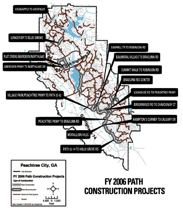 Click here to download a full size map Click here to download a full size mapCouncil also discussed proposed path system projects for the coming fiscal year at last week’s retreat. One was scrapped after much discussion: the construction of a new path going along south Peachtree Parkway in front of the Village Park subdivision going all the way to Harmony Village Apartments. There’s already a path following a similar route in the area, except it’s behind the property extending between Village Park and Harmony Village. City Planner David Rast said the path was put on the list by former Mayor Steve Brown after the city got complaints of cut through pedestrians and vandalism from Village Park residents. The subdivision has privately maintained streets. Police Chief James Murray said there was a vandalism problem that “comes and goes” at Village Park. He added that some Village Park residents there, who are mostly white, may have been a little too confrontational when dealing with the cut through pedestrians, most of whom were minority youths who live in the nearby Harmony Village and Balmoral Village apartment complexes. Other proposed paths include along Ga. Highway 54 East from Robinson Road to the Peachtree East shopping center, which is already used as an informal cart path for residents going to shop just outside the city limits. But the most significant path project residents will see this year wasn’t on this list because it was funded last year: the cloverleaf path and bridge combination that will allow carts to navigate in all directions on Ga. Highway 54 West at the bridge over the CSX railroad. That will link city residents to the west to the Marketplace and Avenue shopping centers as well as the rest of Peachtree City. login to post comments
|
Copyright 2010 - Fayette Publishing, Inc. | Privacy Policy | Terms of Use Policy
Server 4