Search the ArchivesNavigation Contact InformationThe Citizen Newspapers For Advertising Information Email us your news! For technical difficulties |
PTC to choose path design for bridgeThu, 10/25/2007 - 3:23pm
By: John Munford
Would link southside with industrial park; neighbors in Morallion Hills oppose design Peachtree City is moving closer to completing a golf cart bridge that will link the south side of town with the city’s industrial park. 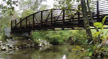 The bridge over Flat Creek is in, but the Peachtree City Council will have to decide how to link the path to the bridge. Photo/John Munford.
The project has been on hold the past few months as neighbors in the area of Mattan Point have questioned the city’s design for the already-installed bridge’s approach paths. Several neighbors spoke at last week’s council meeting, opposed to the current design recommended by city staff. The main concern of the homeowners is that the bridge would increase flooding in the area, as several cited the floods of 1994 and how close they got to flooding one house in the area. City Engineer David Borkowski said the 1994 event was much larger than the anticipated worst-case scenario 100-year flood, and he noted that if the city has a similar one it wouldn’t matter whether the bridge was there or not: there would still be flooding danger of nearby homes. With the current design, Borkowski said, flood water would go mostly over the top of the approaches to the bridge. The bridge was completed in late 2005, and the initial plan was to have the city’s public works department build earth-fill approaches a few feet high or on grade where possible, city officials said. But the bridge was built eight feet above grade due to bad data in the hydraulic model, so that plan had to be scrapped. After the residents expressed concerns earlier this year, the city developed four different design proposals ranging from $382,000 to $971,000 for a bridge spanning the floodplain. The version proposed by city staff would cost $412,000 to build. The design and estimates were compiled by Integrated Science and Engineering of Fayetteville. Kim Cort, who lives on Mattan Point, said the cheaper option would cost the city more in the long run when residents’ homes are flooded and destroyed. Another concern of the residents is the buildup of residual water that would lead to the killing of trees in the area. The City Council delayed its decision two weeks to give the residents a chance to present facts in the matter. Cord said the onus is on the city to hire a hydrologist and do what’s in the best interest of the city. Bill Hall of Feldspar Ridge said he went around the city recently and found 9 of 11 culverts blocked by debris that weren’t properly maintained by the city. Once complete, the project will allow residents on the city’s southside to reach the Federal Aviation Administration’s TRACON facility and other nearby businesses. When the widening of Ga. Highway 74 is complete, there will be a tunnel under the highway nearby so golf carts, bikers and pedestrians can reach the city’s baseball and soccer complex, and a path will stretch from there southward toward Meade Field. login to post comments
|
Copyright 2010 - Fayette Publishing, Inc. | Privacy Policy | Terms of Use Policy
Server 4